Return to the Lanark, Ontario, Canada page - or - return to A McLaren Migration homepage.
Family of Farms
To appreciate the layout of the McLaren farms we need to understand how the land was surveyed. It took a while to piece this together; please be patient and just keep scrolling down the page.
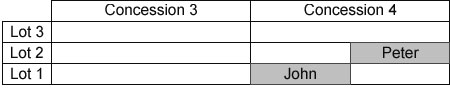
Each "township," in this case Lanark Township, was divided into concessions, parallel strips of land 1.25 miles wide, usually running north and south, but variable with topography. Each concession strip is then partitioned by lot lines, one quarter mile apart. That makes each lot a rectangle, 1.25 miles deep and .25 miles wide. Each concession strip and each strip of lots was numbered, and those numbers would identify a particular lot. Since the area inside each rectangle is 200 acres, and each settler received 100 acres, each would get one half of a lot. Peter, for example, received the East half of Lot 2, Concession 4; John received the West half of Lot 1, Concession 4. Here's the map for 1821.
By 1861 the children of Peter and John had inherited and/or acquired several farms in the immediate vicinity. Here is the map, with descriptions of the owners listed below:
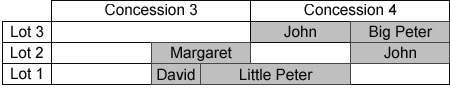
- John, oldest son of the original Peter (did you read about the Scottish naming protocols?), inherited the East half of Lot 2, Con. 4 and has expanded the farm to include the West half of Lot 3, Con. 4.
- Big Peter is the second son of the original Peter and purchased the East half of Lot 3, Con. 4.
- Margaret is the second daughter of the original Peter. She married first cousin James, son of the original John (you might be interested in the "consanguinity" discussion, part of Vignettes). When husband James died in 1846, Margaret and her children assumed control of their farm, the East half of Lot 2, Con. 3. This lot is listed as "urban" in 1901; its western edge borders Lanark Village
- David is the third son of the original Peter, a carpenter by trade, but also farms 50 acres in the East half of Lot 1, Con. 3. Also listed as "urban" in 1901.
- Little Peter, youngest son of the original John (more naming protocols), inherited the West half of Lot 1, Con.4 and added 50 acres from the East half of Lot 1, Con.3.
Census and agricultural records for this period give us a closer look at the McLaren farms:
- In 1851, original John and his wife, their son Little Peter with his wife and four children, a 37 year old widowed male farmer named Brown and an 18 year old female servant are all tending the farm from a one story log home.
- In 1861, John, son of original Peter, is farming with his wife and nine children, ranging in age from 4 to 21. One reason he can handle 200 acres.
- In 1871, Little Peter (a widower) is farming with his son John and John's wife and child, with his daughter Margaret and her child (Margaret is married to her cousin David - but at the moment, David is shown living with his father, Big Peter), and with his youngest children Duncan (19) and Mary (16). That's four adults, two teens, and two children in the same household.
- Big farms don't necessarily mean big chunks of arable land. Land suitable for cultivation was generally located in floodplains, along rivers or adjacent to lakes. Thus, in 1851, John's 200 acres only show 80 under cultivation; 50 as pasture, 29 in crops and 1 as a garden. He had 2 cows, 4 calves, a horse, 2 pigs and 13 sheep. On his 150 acres, Little Peter has 20 acres of crops, 20 acres of pasture, and a quarter acre garden. He has 2 bulls, 4 cows, 4 calves, 2 horses, 13 sheep and 8 pigs.
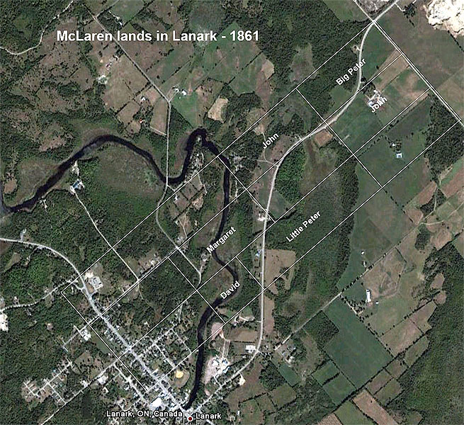
Google Earth gives us an opportunity to see these farms outlined over current geography. The Concession lines became farm roads, and those roads still exist in Lanark. Here is a picture (with grateful thanks to Google) of Lanark today.
Return to the
Lanark, Ontario, Canada page - or - return to
A McLaren Migration homepage.
This site, A McLaren Migration, is maintained by David J. McLaren.
Updated June 4, 2010
Copyright © 2021 David J. McLaren, all rights reserved.
Commercial use of the material on this site is prohibited.